 |
| Fig. 1 Similar To Woods Hole At Fig. 2 |
I recently read a scientific paper which indicated, among other things, that:
"The exact location and depth of the deepest places in each of the world's oceans is surprisingly unresolved or at best ambiguous. Out of date, erroneous, misleading, or non-existent data on these locations have propagated uncorrected through online sources and the scientific literature."
(The Five Deeps, emphasis added). The reason I read that paper, among others, was that I am researching the scientific dicta concerning Thermohaline and AMOC ocean currents depicted in Fig. 1 and Fig. 2.
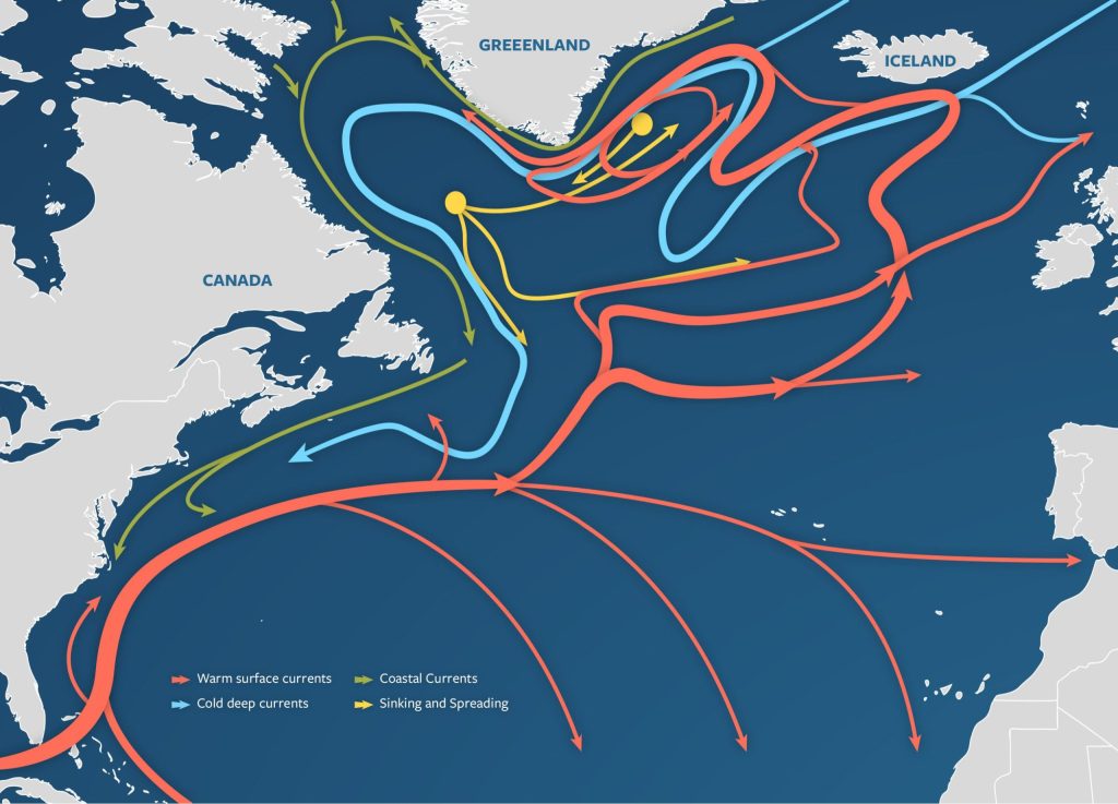 |
| Fig. 2 Woods Hole Version |
I wanted to gather World Ocean Database (WOD) records of the zones where the ups and downs were indicated on graphic portrayals of that current dicta.
One tact I took was to ask an "AI" entity about it. I asked "AI Google" about the AMOC "down welling" latitudes and longitudes, which resulted in helpful information as to latitude and longitude boundaries:
"The "sinking action" (downwelling) of the AMOC occurs at several specific locations in the subpolar North Atlantic and the Nordic Seas.
1. The Labrador Sea * Coordinates: Approximately 53°N to 62°N latitude and 48°W to 64°W longitude.
2. The Nordic Seas (Greenland, Iceland, and Norwegian Seas) * Coordinates: Roughly 65°N to 80°N latitude and 20°W to 10°E longitude.
3. The [Irminger Sea] * Coordinates: Located roughly between 57°N to 63°N latitude and 30°W to 45°W longitude"
 |
| Fig. 3 World Ocean Data Source |
Since I was hunting for WOD temperature, salinity and other in situ data related to the up and down welling in the AMOC dicta, that latitude and longitude information helped me to determine relevant WOD zones within those boundaries (see Fig. 3).
The green color area, the blue colored area, and the purplish colored area (upper right square) are the three groups of zones detailed in today's appendices (HTML zone 7602, HTML group 1, HTML group 2, HTML group 3, HTML all a, HTML all b, and Graphs).
The graphs are averages of all zones in the areas depicted in Fig. 3, the HTML files are WOD in situ values at depths shown.
The "HTML zone 7602" is the narrow area shown (Zone 7602 S.E. of Iceland) in the depiction at Fig. 1 (red rectangle) for which there are only three years of in situ data in the WOD.
The broader pictures that raise questions about non-quantum oceanography based thermohaline and AMOC current dicta can be previewed in additional posts (Quantum Oceanography - 19 and Quantum Oceanography -20).
I will discuss the other down welling and up welling area zones in future posts in this series.
The next post in this series is here.
"Pentagon will remove media offices after judge reinstates New York Times press credentials" (Link)
ReplyDelete