Friday, November 8, 2024

WOD Layers Revisited - 2

Fig. 1 WOD Back From Disaster

I. Disaster Recap

In the previous post of this series I pointed out that the World Ocean Database buildings in Asheville, North Carolina had been damaged and it was offline (Fig. 1).

They are in the process of recovery, so, today we will take a look at what could have been lost so as to remember how valuable that WOD data is.

II. The WOD Technique

The WOD presents its data in a "zone" display based on latitude and longitude columns (Fig. 2).

Fig. 2 WOD Zones

So, I have prepared some graphs utilizing that style.

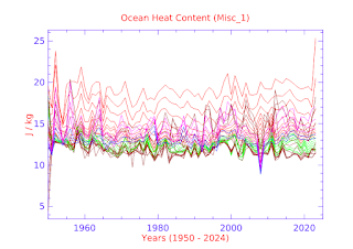
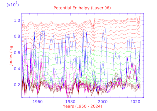
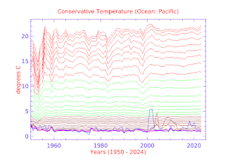
Various appendices contain graphs in which Conservative Temperature and Potential Enthalpy are displayed in latitude and longitude column format to show how ocean temperatures and heat content vary from zone to zone.

Additional layouts by large ocean areas and groups of smaller ocean areas are also shown with the intention to detail in several perspectives and show how the ocean zones vary significantly from place to place and depth to depth.

III. Appendices

Today's appendices are: CT-latitude, CT-longitude, CT-ocean, HO-latitude, HO-longitude, and HO-ocean.

III. Closing Comments

 I can't emphasize enough how much we should value the World Ocean Database organization.

The right wing political forces are addicted to "Koch's cocaine" (oil).

That's why Project For A New American Revolution linked to a decade old Dredd Blog Post "It Takes A Culture To Raise A Compulsive Liar" (and to elect one to Commander In Chief).

Good data is an antidote to lies.

The previous post in this series is here.


HO-ocean

This is an appendix to: WOD Layers Revisited - 2


Group Misc_1 is composed of data from
Mediterranean, Black_Sea, Baltic_Sea,
Persian_Gulf, Red_Sea, Sulu_Sea and
Yellow_Sea sources.

Group Misc_2 is composed of data from
Sea_of_Japan, Seto_Inland_Sea, Hudson_Bay,
Andaman_Sea, Arabian_Sea, Bay_of_Bengal,
and Bering_Sea sources.

Group Misc_3 is composed of data from
Caribbean_Sea, Gulf_of_Mexico, North_Sea,
South_China_Sea, Sea_of_Okhotsk, and
Adriatic_Sea sources.

Depths are in meters.

The following line colors
indicate the depths:

Sea level to 250m (red)
251m to 1000m (green)
1001m to 4000m (brown)
4001m to 5500m (orchid)
5501 to bottom (blue)


HO-longitude

This is an appendix to: WOD Layers Revisited - 2


Group 1 is composed of data from
Longitude Column 0 through Longitude Column 5

Group 2 is composed of data from
Longitude Column 6 through Longitude Column 11


Group 3 is composed of data from
Longitude Column 12 through Longitude Column 17

Group 4 is composed of data from
Longitude Column 18 through Longitude Column 23


Group 5 is composed of data from
Longitude Column 24 through Longitude Column 29


Group 6 is composed of data from
Longitude Column 30 through Longitude Column 35


Depths are in meters.

The following line colors
indicate the depths:

Sea level to 250m (red)
251m to 1000m (green)
1001m to 4000m (brown)
4001m to 5500m (orchid)
5501 to bottom (blue)


HO-latitude

This is an appendix to: WOD Layers Revisited - 2


Depths are in meters.

The following line colors
indicate the depths:

Sea level to 200m (red)
201m to 1000m (green)
1001m to 4000m (brown)
4001m to 5500m (orchid)
5501 to bottom (blue)


CT-ocean

This is an appendix to: WOD Layers Revisited - 2


Group Misc_1 is composed of data from
Mediterranean, Black_Sea, Baltic_Sea,
Persian_Gulf, Red_Sea, Sulu_Sea and
Yellow_Sea sources.

Group Misc_2 is composed of data from
Sea_of_Japan, Seto_Inland_Sea, Hudson_Bay,
Andaman_Sea, Arabian_Sea, Bay_of_Bengal,
and Bering_Sea sources.

Group Misc_3 is composed of data from
Caribbean_Sea, Gulf_of_Mexico, North_Sea,
South_China_Sea, Sea_of_Okhotsk, and
Adriatic_Sea sources.

Depths are in meters.

The following line colors
indicate the depths:

Sea level to 250m (red)
251m to 1000m (green)
1001m to 4000m (brown)
4001m to 5500m (orchid)
5501 to bottom (blue)


CT-latitude

This is an appendix to: WOD Layers Revisited - 2


The layers are shown in Fig. 2

Depths are in meters.

The following line colors
indicate the depths:

Sea level to 250m (red)
251m to 1000m (green)
1001m to 4000m (brown)
4001m to 5500m (orchid)
5501 to bottom (blue)