
The reality of sea level change (SLC) is composed of both sea level fall (SLF) and of sea level rise (SLR) in this era (On the West Side of Zero, Proof of Concept - 3).
Not only that, there are hinge points (The Evolution and Migration of Sea Level Hinge Points).
Concerning hinge points, there is a "twilight zone" for PSMSL tide gauge stations that are within the radius of the circle of hinge points.
Which means that one can be fooled or confused about the nature of SLC at a given tide gauge station, especially when that station is being impacted by ice sheet mass / gravity loss.
That ice sheet mass / gravity loss will cause either SLF, SLR, or both, as a hinge point is moving toward, over, or past that station (The Gravity of Sea Level Change).
II. The European Problem
Note that the majority of tide gauge stations experience only SLR or SLF, but a few stations experience both SLR and SLF.
 |
| Fig. 1 Immingham, England (SLC) |
In the video below, Dr. Mitrovica mentions "the European problem" which was written about in the scientific literature for a long time (note that Dr. Mitrovica says "they did not have a clue" about why tide gauges were recording SLF and SLR).
Some European ports and tide gauge stations did not record SLC like other places in
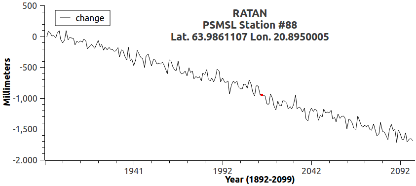 |
| Fig. 2 Ratan, Sweden (SLF change) |
Compare Immingham, England (Fig. 1, Fig. 3) with Ratan, Sweden (Fig. 2, Fig. 4).
Both are in the "np" zone (New Type of SLC Detection Model - 4) which is impacted by the ice sheet gravity of Iceland, as well as the glacial-ice gravity of the glaciers on the lands north of Europe (e.g. Svalbard), and in Europe too (e.g. Finland) (cf. Fig. 5).
 |
| Fig. 3 Immingham, England (SLC) |
This puzzles those who, by choice or neglect, do not have all the pieces of the puzzle (e.g. reality is a big part of the puzzle, such as noting 2012 was a big melt year causing some hinge line movement, etc. @ Fig. 1, Fig. 3).
That would be those who have been professionally lazy for far too long, as the professor in the video below points out.
III. Zone In, Don't Zone Out
 |
| Fig. 4 Rattan, Sweden (SLF) |
The Fig. 5 graphic was presented in the Mitrovica video at the bottom of this post.
The thing to remember about that graphic is that it is a still-shot of a constantly moving target.
 |
| Fig. 5 SLC areas (click 2 enlarge) |
The hinge line (invisible like the invisible gravity that produces it) is where SLF and SLR meet.
The hinge line is also constantly on the move, until all the ice of the world melts or calves into the sea.
The graphic at Fig. 5 shows a snap-shot of the hinge line, which is located where the Dark Blue color turns into Cyan.
If you notice closely, this explains the Ratan vs. Immingham mystery.
Ratan, Sweden (Fig. 2, Fig. 4) is inside the Dark Blue area, that is inside the SLF zone, while a relatively short distance away, Immingham, England (Fig. 1, Fig. 3) is on the Cyan side of the hinge line, that is, is in the SLR zone, but not inside enough.
Immingham, therefore, is having a different SLC experience than Ratan is, even though they are geographically close to one another.
It is the same with tide gauge stations impacted by the Glacier Bay hinge line, in that, ports in cities just as close to one another (as Ratan and Immingham are) on the west coast of the U.S.eh? have very different SLC experiences (Proof of Concept - 3).
IV. How The Software Model Handles It
When I construct a software model that deals with these tide gauge locations, I face the same problem that public works officials face when they look at their tide gauge station records, then compare them with other tide gauge records.
That issue is: "How does one discern the future developments at this station?"
In other words, how do I know to apply, for a particular station, an SLR increase algorithm, or instead, an SLF decrease algorithm?
Algorithms that will generate a projected future path, which I then have to chart on a graph?
I don't want to exaggerate this problem, because as I wrote above, by far the largest percent of acceptable tide gauge stations do not fall within the SLC twilight zone.
The small percentage which do fall into the twilight zone, in that sense comprise a relatively small problem (the public officials there may not think it is a small problem).
For example, to begin with the "np" and "sp" zones, where the problem is most pronounced, have fewer stations overall than the "eq" zone has.
One hundred and two (102) stations fall into the SLF 'suspect zone' (it looks like SLF mode, but may not be) after initial analysis.
Of those, seventy (70) are in the "np" zone (north & polar areas), and the other thirty-two (32) are in the "eq" zone (non-polar, more mid-latitudes).
When the software model's future projecting module runs, it uses a sub-module to analyze and write a record of how it handles these twilight zone stations, and makes a .csv file of records for later analysis of its analysis.
That csv file contains, among others, the following two records which I have cut and pasted here in this post.
Those two records are the first and the last records of that csv file (a file that has been sorted from the least clear to the most clear).
Anyway, here they are:
name,id,zone,inc,dec,4slr,4slf,div [csv column header]What that means is:
IMMINGHAM,286,np,24,25,23,24,2
RATAN,88,np,46,77,45,76,64
The tide gauge station at IMMINGHAM is PSMSL station id number 286 in zone np. In the historical time frame analyzed (1960-2013), station #286 had 24 SLR events, 25 SLF events, 23 other SLF indicators, 24 other SLR indicators, and ended up with a divide factor of 2.BTW, the divide-factor value (0-100) indicates the strength of clarity, so, the closer the hinge line is likely to be (i.e. how near it is to the tide gauge station) the lower the divide-factor value will tend to be.
The tide gauge station at RATAN is PSMSL station id number 88 in zone np. In the historical time frame analyzed (1892-2014), station # 88 had 46 SLR events, 77 SLF events, 45 other SLF indicators, 76 other SLR indicators, and ended up with a divide factor of 64.
Thus, the lower the divide-factor value is, the less clear the future SLC status is (in terms of being clearly SLF, or clearly SLR at a time certain).
V. Conclusion
Thus, IMMINGHAM did not qualify for a future projection of either SLR or SLF, because it is too "twilight zone" (too near the hinge line).
But RATAN did qualify for a future projection out to the year 2099, because the model could tell clearly that the tide gauge station there is in SLF mode.
Which means that a melting ice sheet or melting mountain glacier area near enough to the tide gauge station that its moving hinge line impacts that station in a way that leaves the future SLC uncertain.
So, the model will not at this time generate a future projection.
Instead, it will wait for more annual data during the upcoming years, until that data makes it clear enough to do a future SLC projection.
Again, most (about 93%) of the usable (to the demanding Dredd Blog model) 487 stations out of 1,417 total PSMSL stations, have historical data making it clear enough to do future projections about those stations.
So, I have an easier job than those public works officials whose tide gauges are located in the twilight zone.
And I have an easier job of it than the other public works officials who are in the clearly "targeted for extinction" zone.
Which is the expanding extinction zone that Oil-Qaeda is putting us all into day by day.
The next post in this series is here, the previous post in this series is here.
Dr. Jerry Mitrovica on the fingerprints of SLC:
Great work, Dredd! This thing is clearly coming along. Since people in the business of maintaining or running ports need this information, do you see any need to "reach out", as it were, to maybe alert some of these clowns to what's comin' at 'em? Or do you think it's already too late?
ReplyDeleteTom
Enormous icebergs break off from Svinafellsjokull glacier in Iceland
ReplyDeletehttp://www.sott.net/article/306088-Enormous-icebergs-break-off-from-Svinafellsjokull-glacier-in-Iceland
- and these are just the ones someone was lucky enough to witness!
Tom