 |
| Fig. 1 Zones with Arctic Currents |
I. Foreward
The graphic at
Fig. 1 shows the
WOD Zones featured in this series.
These zones are where currents from the south flow through them into Arctic area waters.
Two sets of graphs (
Section IV) detail the
Conservative Temperature and the
Absolute Salinity of the seawater (in those zones on opposite sides of the Arctic Ocean) down as far as
in situ measurements have been recorded in the
World Ocean Database.
The graphic at
Fig. 2 shows
the traditional concept of the two currents featured in this series.
As you can see, the historical character of these currents was that one is cold but the other is warm.
The textbook case was that the
Bering Sea current (light blue color in
Fig. 2) was cold, while the
North Atlantic side current was warm (red color in
Fig. 2).
The currents mixed together in the
Beaufort Gyre which ostensibly cooled the warmer water while warming the colder water in various degrees (until equilibrium was reached).
II. Things Have Changed
In a
Dredd Blog post a few years ago I suggested that the
Bering Sea currents flowing into the Arctic area would change from the traditional temperatures to warmer temperatures, and then have a noticeable impact on the Arctic.
Most of you reading this post know by now that what I wrote about then has turned out to be
an underestimate in some senses.
Recently the Bering Sea itself was without its ice cover for the first time since we have been keeping records of that sea.
Some of the comments from experts explain the phenomenon: “
This winter is so far below any previous season ... warm water in the Bering Sea" (
NASA); "
We've fallen off a cliff: very little sea ice remains in the Bering Sea" (
NOAA).
One scientific magazine went all out:
"Winter sea ice cover in the Bering Sea did not just hit a record low in 2018; it was half that of the previous lowest winter on record (2001), says John Walsh, chief scientist of the International Arctic Research Center at the University of
Alaska Fairbanks. “There’s never ever been anything remotely like this for sea ice” in the Bering Sea going back more than 160 years, says Rick Thoman, an Alaska-based climatologist with the National Oceanic and Atmospheric Administration.
...
But until recently the water there was reliably cold enough in autumn that when winds did blow from the north, sea ice would still spread. The last few years have seen unusually warm ocean waters in the Bering. Research meteorologist Nick Bond and others think this is “a lingering hangover” of a larger marine heat wave—dubbed “The Blob”—that lay off the west coast of the U.S. and Canadian mainland from 2014 to 2016. Bond, who works for NOAA’s Pacific Marine Environmental Laboratory, thinks some of those warm waters followed ocean currents up into the Bering and left a deep reservoir of warmth that impeded ice formation, although he has not yet formally studied this."
(
Scientific American). Match those observations in
Scientific American with what is in a
Dredd Blog post from several years ago:
"1) warm water will flow up through the Gulf of Alaska from "The Blob" into and through the Bering Strait; 2) It will make its way into the Chukchi Sea; 3) Then if will flow across into and through the Fram Strait; and 4) Finally it will then flow around both sides of the coast of Greenland"
(
The Question Is: How Much Acceleration Is Involved In SLR? - 4, cf
Fig. 3). Ok, so let's move on to that flow from the Pacific as it moves over to the North Atlantic after flowing both east and west of Greenland (around Greenland,
Fig. 4).
In short, the
new Arctic is less like the
old Arctic every year (
Alien Waters: Neighboring Seas Are Flowing into a Warming Arctic Ocean).
III. Impact on Greenland
I expect an increasing impact on the
Northern Greenland Tidewater Glaciers (
Greenland 2.0 - 2).
The characterization of that impact
on tidewater glaciers, but not other types of glaciers, is detailed in
OMG, the Water's Warm! NASA Study Solves Glacier Puzzle.
NASA realized that the
new Arctic (warmer water flowing in from both North Pacific and North Atlantic) required a new look at Greenland's tidewater glaciers.
So, NASA quickly started the OMG project.
Hopefully they will do some work in the
Lincoln Sea area, because it is going to be impacted too:
"Along the continental margins of the Arctic Ocean basin, narrow boundary currents are hypothesized to house intense large-scale advection that is critical in the general circulation of Arctic waters. From the Bering Strait, Pacific Ocean waters flow counterclockwise (cyclonically) along the northern shores of Canada, passing through the Lincoln Sea."
(
Wikipedia, Lincoln Sea, emphasis added). I am looking into the history of research on the Lincoln Sea and will detail relevant data in future posts.
IV. Conclusion (and graphs)
Nevertheless,
current events in Greenland are dwarfed by
current events in Antarctica (
Mysterious Zones of Antarctica - 4).
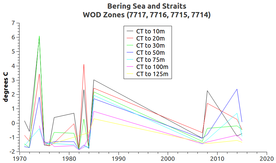
The following graphs show that North Pacific Ocean seawater flowing through the Bering Sea and Bering Strait into the Arctic
is not as cool as it once was, and that the North Atlantic Ocean seawater flowing into the Arctic will now
mix more easily (in the Beaufort Gyre) with the North Pacific seawater.
The graphs below are laid out as shown in
Fig. 1, in the sense that there are
two groups of WOD Zones (Bering and Atlantic).
Each group contains
three layers of zones based on the same
latitude boundaries for each layer (Layer 1, Layer 2, and Layer 3).
Within each layer is a division for
seawater temperature (CT) and
seawater salinity (S
A) at
up to 33 depths, depending on the maximum depth of the ocean at those zones (e.g. the Bering Strait is shallower than the others).
Pacific / Bering Sea Group
Layer 1 (WOD Zones 7717, 7716, 7715, 7714):
 |
| Bering: Conservative Temperature (Layer 1, to 125m) |
 |
| Bering: Conservative Temperature (Layer 1, to 600m) |
 |
| Bering: Conservative Temperature (Layer 1, to 900m) |
 |
| Bering: Absolute Salinity (Layer 1, to 125m) |
 |
| Bering: Absolute Salinity (Layer 1, to 600m) |
 |
| Bering: Absolute Salinity (Layer 1, to 900m) |
Layer 2 (WOD Zones 1617, 7617, 7615, 7614):
 |
| Bering: Conservative Temperature (Layer 2, to 125m) |
 |
| Bering: Conservative Temperature (Layer 2, to 200m) |
 |
| Bering: Absolute Salinity (Layer 2, to 125m) |
 |
| Bering: Absolute Salinity (Layer 2, to 200m) |
Layer 3 (WOD Zones 1516, 1517, 7517, 7516, 7515, 7514):
 |
| Bering: Conservative Temperature (Layer 3, to 125m) |
 |
| Bering: Conservative Temperature (Layer 3, to 600m) |
 |
| Bering: Conservative Temperature (Layer 3, to 1300m) |
 |
| Bering: Conservative Temperature (Layer 3, to 3500m) |
 |
| Bering: Conservative Temperature (Layer 3, to >5500m) |
 |
| Bering: Absolute Salinity (Layer 3, to 125m) |
 |
| Bering: Absolute Salinity (Layer 3, to 600m) |
 |
| Bering: Absolute Salinity (Layer 3, to 1300m) |
 |
| Bering: Absolute Salinity (Layer 3, to 3500m) |
 |
| Bering: Absolute Salinity (Layer 3, to 5500m) |
Atlantic Group
Layer 1 (WOD Zones 7700, 1700)
 |
| Atlantic: Conservative Temperature (Layer 1, to 125m) |
 |
| Atlantic: Conservative Temperature (Layer 1, to 600m) |
 |
| Atlantic: Conservative Temperature (Layer 1, to 1300m) |
 |
| Atlantic: Conservative Temperature (Layer 1, to 3500m) |
 |
| Atlantic: Absolute Salinity (Layer 1, to 125m) |
 |
| Atlantic: Absolute Salinity (Layer 1, to 600m) |
 |
| Atlantic: Absolute Salinity (Layer 1, to 1300m) |
 |
| Atlantic: Absolute Salinity (Layer 1, to 3500m) |
Layer 2 (WOD Zones 7600, 1600)
 |
| Atlantic: Conservative Temperature (Layer 2, to 125m) |
 |
| Atlantic: Conservative Temperature (Layer 2, to 600m) |
 |
| Atlantic: Conservative Temperature (Layer 2, to 1300m) |
 |
| Atlantic: Conservative Temperature (Layer 2, to 3500m) |
 |
| Atlantic: Absolute Salinity (Layer 2, to 125m) |
 |
| Atlantic: Absolute Salinity (Layer 2, to 600m) |
 |
| Atlantic: Absolute Salinity (Layer 2, to 1300m) |
 |
| Atlantic: Absolute Salinity (Layer 2, to 3500m) |
Layer 3 (WOD Zones 7500, 1500)
 |
| Atlantic: Conservative Temperature (Layer 3, to 125m) |
 |
| Atlantic: Conservative Temperature (Layer 3, to 600m) |
 |
| Atlantic: Conservative Temperature (Layer 3, to 1300m) |
 |
| Atlantic: Conservative Temperature (Layer 3, to 2000m) |
 |
| Atlantic: Absolute Salinity (Layer 3, to 125m) |
 |
| Atlantic: Absolute Salinity (Layer 3, to 600m) |
 |
| Atlantic: Absolute Salinity (Layer 3, to 1300m) |
 |
| Atlantic: Absolute Salinity (Layer 3, to 2000m) |
The next post in this series is
here.


"Almost all of the ice to the north of Greenland is quite shattered and broken up and therefore more mobile," Ruth Mottram of the Danish Meteorological Institute told the Guardian. "Open water off the north coast of Greenland is unusual. This area has often been called 'the last ice area' as it has been suggested that the last perennial sea ice in the Arctic will occur here. The events of the last week suggest that, actually, the last ice area may be further west."
ReplyDelete(link)