 |
| Fig. 1 Is this a "Hot Glacier?" |
I. Background
Regular readers know that I have had my eyes on ice sheets, ice shelves, and glaciers for some time now.
Recently, while reading Thermodynamic Equation Of Seawater - 2010 (TEOS-10) manuals, it dawned on me that I could use the toolkit (along with World Ocean Database (WOD) in situ measurements) to take a look at what water temperatures were melting ice sheet glaciers that had made their way to the ocean.
As you know, those tongues of ice-sheet ice-streams eventually branch out into glaciers, which are called tidewater glaciers when they flow into the oceans and then interface with seawater (Water terminating glaciers, Related, Frontal Melting @ Tidewater Glaciers, Cryosphere Frontal Melting).
 |
| Fig. 2 Tidewater Glacier Areas |
A favorite area of inquiry, when taking a look at those glaciers, is the "grounding line" area (Grounding Lines, Convection-Driven Melting near the Grounding Lines).
When I read that ocean water temperature was paramount, I decided to go all in to check it out (Ocean temperatures dictate glacier calving).
Adding to that was some rhetoric I came across that categorized glaciers with a puzzling description of: Cold, Temperate, or Polythermal (Thermodynamics of Glaciers).
Excuse me for having thought all along that glaciers were all cold ("hot" or "warm" glaciers anyone?).
 |
| Fig. 3a Antarctica |
 |
| Fig. 3b Glacier Bay |
 |
| Fig. 3c Greenland |
 |
| Fig. 3c Patagonia |
 |
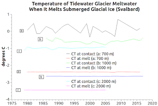
| Fig. 3d Svalbard |
II. Keyboarding Into Action
I lashed out a bit at the warming commentariat for having used "warm" and "hot" to mislead me (Questionable "Scientific" Papers - 17, On Thermal Expansion & Thermal Contraction - 32).
Now, I am letting regular and irregular readers know that I have completed two new modules that calculate the melting temperatures of glacial ice that is submerged.
One module uses seventy-three individual WOD Zones that are along coastlines where tidewater glaciers are being melted and calved by VERY COLD WATER.
The other module groups zones into "areas" called Glacier Bay, Svalbard, Patagonia, Greenland, and of course Antarctica (e.g. today's graphs).
III. Oh, And Did I Mention The Graphs?
The graphs at Fig. 3a - Fig. 3d feature data the tidewater glacier areas shown on the WOD Zone map at Fig. 2.
The software procedure for determining the Conservative Temperature (CT) of seawater was explained at The Art of Making Thermal Expansion Graphs.
Those graphs at Fig. 3a - Fig. 3d show the seawater temperature at the two or three top lines, representing "CT at contact".
The bottom two or three lines on those graphs represent "CT at melt."
Let me explain.
Tidewater glaciers are glaciers that have substantial portions submerged under the ocean because they slide from land into the sea.
The depth of the water at the "CT at contact" is 700 meters, 1000 meters, and 2000 meters, as is the "CT at melt".
The thermodynamic circumstance which determines the melting point in any give case is CT (degrees C), Absolute Salinity (SA) in g/kg, and Pressure (P) in dbars at that depth.
The CT is just above the freezing point of seawater in that circumstance, after the melt.
The way it happens is that the second law of thermodynamics is in play.
Simply put, an area of water with a CT above the ice CT it comes in contact with will experience a transfer of CT from itself to the ice and they both will end up with a state of equilibrium (an equal CT).
 |
| Fig. 4 Example melt |
Imagine arrows flowing from the top lines, as the CT diminishes, down to the bottom lines (down to the ice as it disintegrates into seawater).
They become one (Fig. 4).
At that point different things happen, depending on the in situ circumstances.
The main thing I want to point out in today's post is the deadly cold temperature of the seawater and of the ice (even after the melt takes place).
IV. TEOS-10 Functions
Now, I will describe the thermodynamics taking place, and show the TEOS-10 functions used to calculate the sequence of events:
Gather: World Ocean Database (WOD) in situ values:
1) "T" (in situ seawater temperature),
2) "SP" (in situ practical salinity), and
3) "height" (a.k.a. depth) @ "latitude" ...
Determine:
4) "Z" (from in situ depth @ latitude: gsw_z_from_p).
5) "P" (pressure: gsw_p_from_z),
6) "SA" (Absolute Salinity: gsw_sa_from_sp),
7) "CT" (Conservative Temperature: gsw_ct_from_t, which makes the a,b, and c lines at the top of the graphs).
8) "t_ih" (the freezing CT of sea water per in situ conditions: gsw_t_freezing_exact),
9) "w_ih" (the ice fraction: gsw_ice_fraction_to_freeze_seawater)
10) "sa_freeze", "ct_freeze", "w_ih_final" (when "w_ih_final" is zero after executing gsw_melting_ice_into_seawater, then "ct_freeze" is the lowest the temperature of the result of the ice having melted into the seawater can be ("Note that when w_Ih_final = 0, the final seawater is not at the freezing temperature." - TEOS-10 source code comment).
This makes the a,b,and c lines at the bottom of the Fig. 3a - Fig. 3d graphs).
V. Conclusion
A couple of decades after the industrial revolution (which began circa 1750), the glaciers and ice sheets began to melt above sea level.
Eventually they also began to melt below sea level as in situ temperatures increased (Weekend Rebel Science Excursion - 54, Questionable "Scientific" Papers - 3).
The thermodynamic properties I am studying give new meaning to "warm" water that melts ice doesn't it?
The next post in this series is here.
Uh oh ...
ReplyDeletehttps://www.washingtonpost.com/news/energy-environment/wp/2018/02/06/a-key-part-of-earths-ozone-layer-is-failing-to-recover-and-scientists-dont-know-why/?utm_term=.077c98f326f6
Not good this for sure and in the context of how ice behaves at the CT line, there may be 'more' to the story than heat transfer between solid and liquid water in the presence of UV radiation.
Deletehttps://www.space.com/38321-interstellar-ice-liquid-ultraviolet-light.html