 |
| Fig. 1 Glaciers in East Turkey (blue circle) |
I was fooled while trying to figure out the perplexing tide gauge history in the PSMSL database for the Black Sea area ("4.1 ft. of SLC ???").
A regular reader wondered about the precipitation records available, which would have an impact on outflow from the Danube, Dniestr, and other rivers flowing into the Black Sea.
I researched that issue then added to that post a Section V. concerning that issue.
But that did not solve some of the mystery and flux in the tide gauge record which caused me to keep pondering.
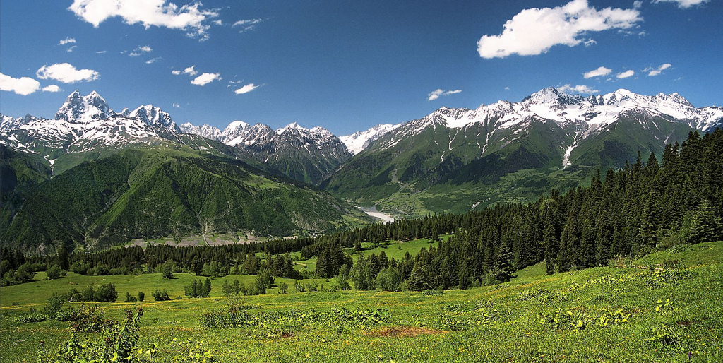 |
| Fig. 2 Georgia Glaciers (BlackSea) |
I hypothesized in my thinking that perhaps melting glaciers were feeding the major rivers that outflowed into the Black Sea.
Nope (read that post if you haven't yet).
Finally, it dawned on me that I had forgotten to consider ghost water (The Ghost-Water Constant, 2, 3, 4).
As it turns out, a number of countries have beaches along the Black Sea.
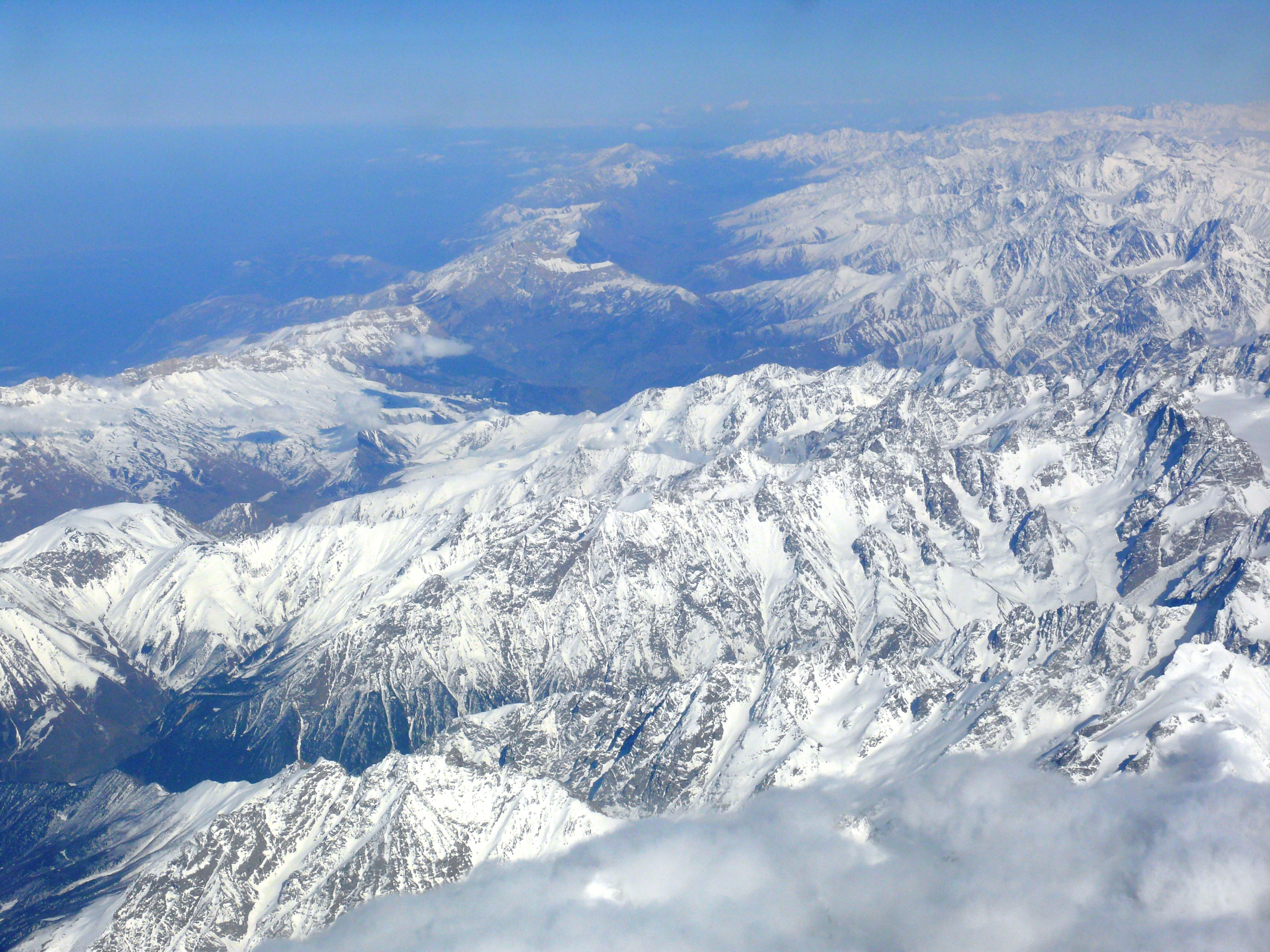 |
| Fig. 3 Caucus Mountains (Black Sea) |
This analysis is not completely solved, but the part of the puzzle that was right in front of my eyes (but I could not see it), led me to realize what others go through.
I should have known better, having read about ghost-water, having written about it, and having put forth a hypothesis about the magnitude of the influence of ghost-water, and of course after having seen proof of it (Proof of Concept - 3, Proof of Concept - 5).
Anyway, a lot of people have been, like me, the blind man in the group of blind men around the Elephant (The Warming Science Commentariat).
I am still on the case, pondering the various hinge lines (The Evolution and Migration of Sea Level Hinge Points) and gravity of this situation in the Black Sea (The Gravity of Sea Level Change, 2, 3, 4).
I just can't seem to get away from it.
A few examples of Black Sea glacial reality:
Kluhor (Klukhor) Glacier is in the Caucasus Mountains west of Mount Elbrus. It drains into the Teberda River and then the Kuban River and eventually Krasnodar Reservoir and the Black Sea. The Krasnodar Reservoir is primarily a flood control and irrigation management reservoir. Here we examine three glaciers each experiencing the familiar pattern in the Caucasus Mountains of retreat with expansion of proglacial lakes. As the area and number of glacier is reduced, the number and area of alpine lakes is increasing, note Khimsa Glacier, Georgia, Psysh Glaciers, Russia, and Gora Bashkara, Russia. Stokes et al (2006) note that 94% of Caucasus Mountain glaciers retreated from 1985 to 2000 and it is clear from the aforementioned that the trends continues. (AGU Blogosphere, emphasis added).The next post in this series is here, the previous post in this series is here.
...
Khimsa Glacier is a rare significant glacier south of the main crest of the Caucasus Mountains in Georgia. The glacier drains north to the Bzyb River, and then the Black Sea. The rivers upper reach is quite undeveloped and there is no hydropower along the river to date. The glacier flows from an elevation of 3000 m to 2650 m. In 1998 the glacier was 1.6 km long with a narrow terminus at the red arrow. At the transition to the glacier’s upper eastern slopes at Point A, there is only one small rock exposure. By 2013 the glacier has retreated 400 m to the yellow arrow, having lost 25% of its length in 15 years. The area of bedrock exposed on the upper eastern slope, at Point A, is significant now indicating thinning even high on the glacier. The glacier will soon separate near Point A into an upper and a lower section. In the Google Earth image the current terminus is indicated with orange dots and the glacier flow with blue arrows. Like Psysh Mountain glaciers 25 km north Khimsa Glacier thinning high on the glacier indicates it cannot survive current climate. Caucasus Mountain glaciers are in a period of rapid retreat (Shagedenova et al, 2009), that is attributed mainly to rising summer temperatures. Khimsa Glacier’s retreat parallels that of glaciers along the main crest of the Caucasus such as Kirtisho or Azau Glacier, though as a percent of total area lost it is greater. (AGU Blogosphere, emphasis added).
...
Changes in the area and number of glaciers in the Georgian Caucasus Mountains were examined over the last century, by comparing recent Landsat and ASTER images (2014) with older topographical maps (1911, 1960) along with middle and high mountain meteorological stations data. Total glacier area decreased by 8.1 ± 1.8 % (0.2 ± 0.04 % yr−1) or by 49.9 ± 10.6 km2 from 613.6 ± 9.8 km2 to 563.7 ± 11.3 km2 during 1911–1960, while the number of glaciers increased from 515 to 786. During 1960–2014, the total ice area decreased by 36.9 ± 2.2 % (0.7 ± 0.04 % yr−1) or by 207.9 ± 9.8 km2 from 563.7 ± 11.3 km2 to 355.8 ± 8.3 km2, while glacier numbers decreased from 786 to 637. In total, the area of Georgia glaciers reduced by 42.0 ± 2.0 % (0.4 ± 0.02 % yr−1) between 1911 and 2014. The eastern Caucasus section had the highest retreat rate of 67.3 ± 2.0 % (0.7 ± 0.02 % yr−1) over this period, while the central part of Georgian Caucasus had the lowest, 34.6 ± 1.8 % (0.3 ± 0.01 % yr−1), with the western Caucasus intermediate at 42.8 ± 2.7 % (0.4 ± 0.03 % yr−1). (Cryosphere).
Thanks Dredd
ReplyDeleteChased back to the Jan 'Ghost Water' post for a refresher. Key Learning:
"The lesson is that the circumference, i.e. the length of the coastline (e.g. jagged vs. smooth) has an effect on the outcome of the calculation, as does an ice sheet's total mass."
Note: The image of the Caucus Mtns very helpful.
Similarly, not many would 'guess' that Louisiana has more 'coastline' then #6-Texas for the exact same reason.
LA is # 5 behind #1 Alaska, #2- Florida, #3-CAL, #4-Hawaii, #5 LA. SLR is already causing big problems down that way.
Mark,
DeleteYou quoted "The lesson is that the circumference, i.e. the length of the coastline (e.g. jagged vs. smooth) has an effect on the outcome of the calculation, as does an ice sheet's total mass."
The pure geometry indicates that there is a maximum of an ~85% ghost-water constant.
Recall that I chose to use ~28% to account for the variances in coastlines, coastal area depths, and the like (The Ghost-Water Constant - 4).
We have to remember that ghost-water is already in the ocean, so when we talk about its impact on SLC we are not talking about something caused by adding any water to the ocean.
What we are talking about is relocation of that water.
As the ice sheet melts its power to hold ghost-water diminishes along the lines of Newton's Law of Gravity.
Consequently, the water is relocated in the direction of the equator by the Earth's rotational pull.
Some ghost-water is left all along its path toward the equator, so the amount eventually reaching the equatorial areas is not the total amount of the ghost-water released.
Traditionally, the IPCC has not even included ice sheet melt-water or calved icebergs (which do increase the amount of water in the oceans) in its SLC projections.
So, one can hardly expect that they will soon consider ghost-water (everything except thermal expansion is ghost to them).
The better scientists will see the reality of ghost-water soon enough, so I will leave it up to them to urge the IPCC to open their eyes, and to see the ghost-water in the morning when they wake up to smell the coffee.
This current post which you commented on shows that even I do not think about the gravity of SLC naturally either.
Without struggling against my historical, culturally induced unawareness of ghost-water, my analysis is "worst than previously thought" too.
Many thanks for the follow up explanation Dredd! Even though I sit up front in your lecture hall in order to capture as much info as I can, there certainly is plenty of moving parts here and a corresponding complexity. Like all attempts to interpret what nature is 'doing', the challenge is to understand what is occurring and finding an accurate explanation that covers all the inputs. Really appreciate your devotion to that!
DeleteThis will put a crimp in a lot of people's "expectations":
ReplyDeletehttps://www.newscientist.com/article/2082628-unexpected-antarctic-ice-melt-may-trigger-2-metre-sea-level-rise/
Unexpected Antarctic ice melt may trigger 2 metre sea level rise
[Keep up the good work, Dredd.]
Tom
IMO, everyone should read the link Tom provided.
Delete