 |
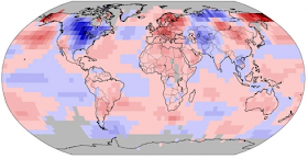
| Earth viewed from space |
The result of that calculation is then expressed in cubic feet, cubic kilometres, or cubic miles.
That is, if an ice measurement and calculation were to be expressed in square feet, square kilometres, or square miles, it would have a different meaning.
If the result is expressed in square units rather than in cubic units, it is an expression of the area or the extent of that ice, not of the volume of that ice:
l * w = area (e.q. square feet, ft2)(How Fifth Graders Calculate Ice Volume - 2). ESA's Cryosat satellite uses the volume formula in order to calculate the quantity of Arctic ice:
l * w * h = volume (e.q. cubic feet, ft3)
While these observations on ice extent provide invaluable data, this is only part of the picture. In order to understand fully how climate change is affecting these remote but sensitive regions, there remains an urgent need to determine exactly how the thickness of land and sea ice is changing. CryoSat is Europe's first mission to address this.(ESA Cryosat, emphasis added). People had gotten into the habit of using the word "extent" to argue for and against global warming induced polar ice cap melt.
CryoSat-2 carries sophisticated technologies to measure changes at the margins of the vast ice sheets that overlay Greenland and Antarctica and marine ice floating in the polar oceans. By accurately measuring thickness change in both types of ice, CryoSat-2 will provide information to complete the picture and lead to a better understanding of the role ice plays in the Earth system.
Those arguments were based on how much extent of coverage of the water surface there was.
But the word "extent" does not tell us about volume / quantity so we need to use the word "volume" now because we have the satellite that can measure thickness.
Thus, we can now more accurately determine expected sea level rise because that involves the volume of ice, not the extent:
In the years since 2006, this thinning has been characterised and linked to Synthetic Aperture Radar interferometry measurements of ice flow, which show an increased flow rate into the sea. The rate of thinning is stunning, at about 16 m per year.(Earth's Changing Ice, emphasis added). Anyway, this last year of polar vortex weirdness has caused an out-of-trend cold over the U.S. and has increased the ice volume of the floating Arctic ice, but not the Antarctic ice.
While this has been reported by several groups, it has been put into perspective by the late-2009 report by the Scientific Committee on Antarctic Research Antarctic Climate Change and the Environment, which projects a sea level rise of about 1.4 m by 2100, significantly higher than the
well-known 28–43 cm projections of the Intergovernmental Panel on Climate Change. The difference is largely attributable to melting of the ice caps at their base by warming oceans.
2013-14 Cold temps over U.S. & Canada
Change is not limited to Antarctica. Greenland, being smaller and at lower latitudes, may be even more vulnerable. Gravity measurements from the NASA/German Aerospace Centre (DLR) GRACE mission have revealed large-scale mass changes and even sensitive GPS receivers placed around the coast show signs of uplift as the burden of ice is reduced.
So indeed, in the decade since the CryoSat mission was proposed, the signs of change in the polar regions have become unambiguous, and this trend is also clear in the four years since CryoSat-2 was approved.
Additionally, the number of tornadoes in the U.S. has decreased due to that against-the-trend (On The Origin of Tornadoes - 3) cold spell.
The arrival of an El Niño is expected by some scientists, which would upset the apple cart as well, helping some places but not others:
(WaPo, A super El Niño on the way?, cf. NOAA). The gist of this is that when the Global Climate System is damaged as it is, and continues to be damaged even more, accurately predicting anything other than weird climate and weird weather is more difficult.
- Large amounts of heat from the tropical Pacific ocean would be released into the atmosphere, likely raising global temperatures to record-setting levels
- Above normal rain would be favored in California.
- Hurricane activity would likely be suppressed in the Atlantic
- Washington, D.C. might see depressed snow next winter. Our two least snowy winters on record (0.1 inches at Reagan National Airport) coincided with two of the three strongest El Nino events on record (1997-1998 and 1972-1973).
- Link: List of El Niño impacts on North America
So Dredd Blog predicts surprising, weird weather until we are no longer addicted to fossil fuels, and instead are using renewable, clean resources such as wind, solar, tidal, geothermal, and other non-polluting fuels.
The next post in this series is here, the previous post in this series is here.

No comments:
Post a Comment