 |
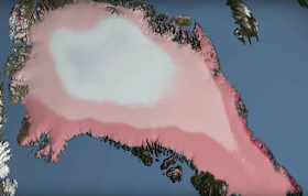
| Fig. 1 Zones of progressive melt |
The video below shows recent GRACE satellite discoveries concerning loss of gravity at Greenland, confirming the zonal melt progression by the Dredd Blog software projection of that time (which was that it would begin to melt from the coastal edges, then move inward toward the core ice sheet).
At 3:00 into this video, the GRACE satellite project is discussed in terms of its detection of melt dynamics, depicted as pink areas, showing that Greenland is in fact melting as the graphic at Fig. 1 contemplated:
NOTE: the initial stop-frame picture above, with the red arrows, is not Greenland, it is Antarctica ... we all make mistakes ... (the video is spot on)
This full series, before today's post, is: (The Question Is: How Much Acceleration Is Involved In SLR?, 2, 3, 4, 5, 6, 7, 8, 9).
Expect more acceleration, because the water underneath the ice shelves is warming at an accelerating rate:
Here are some screens from the video which show the zonal pattern of melt (see Fig. 1 above), proceeding from the coast toward the inland areas in bands (darker pink means more melt, white means no melt):
The next post in this series is here, the previous post in this series is here.


"The National Oceanic and Atmospheric Administration predicts sea levels will rise as much as three feet in Miami by 2060." - link
ReplyDelete(1 in 9 Deaths are from Air Pollution)
ReplyDelete